When the Mediterranean rages: our interview with Navimeteo’s expert
Vuoi salvare articoli per un rapido accesso?
Sali a bordo della community DN Plus.
Per te, un'area riservata con: approfondimenti esclusivi, i tuoi articoli preferiti, contenuti personalizzati e altri vantaggi speciali
Accedi RegistratiGianfranco Meggiorin of the Navimeteo Centre explains the origin of the violent storm lines that hit our seas in recent days
Gianfranco Meggiorin of the Navimeteo Centre explains the origin of the violent storm lines that hit our seas in recent days
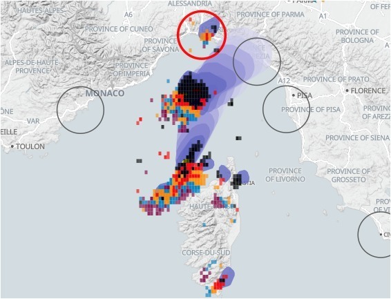
The violent storm lines that hit our seas in recent days and on Thursday 18 August various areas of Provence, Corsica, Liguria, Tuscany, generating very violent winds, are a subject of extraordinary and unfortunately dramatic topicality. Everyone would like to understand better, especially sailors, professionals and boaters and seafarers who witnessed and suffered the intensity of the event on the coasts.
Many wonder if it was predictable, how could have avoided being surprised, if there is a risk that it will repeat and in which areas. To give some answers to these questions, Daily Nautica, which recently inaugurated the Weather forecast column, asked Gianfranco Meggiorin, who coordinates the Navimeteo Center, for an opinion. Navimeteo is operating 24/7 and dedicated to marine weather services. Here is his opinion.
Talking and describing this meteorological event a posteriori is useful but much more interesting is to think about how these phenomena are produced and what are the warning signs that every navigator could use in order to be safer. We could talk about it for a long time. I prefer to summarize some essential points, perhaps taken for granted, that derive from a life dedicated to navigation and marine meteorology. They are certainly ideas that deserve further study.
A torrid summer with a very hot sea
Everyone, not only researchers but also the less experienced, has found the unusual character of this summer, characterized until a few days ago by light winds, the stagnation of hot and humid air in the lower layers and an almost leveled pressure. It was a long manageable period for navigation, the first storm or the squall line would have drawn strength and extraordinary energy from the thermal contrasts.
The lines of instability
Many call them “squall lines”, they are inflections of cold air that contrast with the hot and humid air and form a series of thunderstorms, close to each other that move at varying speeds. On the sea they accumulate energy which they discharge with strong gusts of direction and variable intensity. They have always been feared in the Mediterranean because they can also occur in situations of almost levelled pressure, with a low gradient and in manageable marine weather conditions before and after the phenomenon.
Clusters of wind, heavy rains, winds and gusts with hurricane intensity
I emphasize that the most critical aspect of these phenomena is precisely due to the fact that they can also occur in marine weather conditions that are considered mainly manageable as regards the wind and sea situation. These systems can travel at incredible speed compared to the motion of the units on the sea, in this circumstance at about 100 Km/h of displacement and this factor also increases the phenomenon of gusts with storm force. The other feature of the phenomenon is that it develops in various patchy maritime areas, making the choice of safe areas more difficult.
In the worst period
The storm lines of recent days have produced violent phenomena at sea and on the coasts at the very “busy period” of the pleasure craft and yachting season, with very crowded ports and many boats iat the anchor or at buoys. This exposed a very high number of units to the risk of being hit by the storm line when in other periods many would have found shelter more easily in safe havens.
The greatest danger: the proximity to the coasts
The anchorages in the calm bays are the most magical moment of a cruise and it is reassuring to be in a gulf protected at anchor when the wind blows strongly from a certain direction. You can handle a gale when the wind is blowing from the coast to the sea, with a good anchorage but there is nothing more insidious than a sudden, gusty wind that changes direction generated by a strong storm. All this becomes even more extreme and dangerous when sea whirlpools and many lightning approach the area.
Sometimes the determination to move away from the coast or to leave an anchorage made it possible to overcome very difficult situations. It is clear that the decision to “go out” so as not to suffer the fury of the wind and the sea close to the coast is not easy, everything happens very quickly, but on many occasions this has allowed sailors to manage the emergency. These phenomena have a rather short duration and generally the situation improves rapidly as soon as the “squall line” has passed.
The reliability of weather forecasts and models
This is a subject that would require extraordinary study. There must be awareness that the weather on the sea, but not only on the sea, has made incredible progress but still reveals significant limits since knowing in advance the position and intensity of a violent thunderstorm is not easy.
However, it is good to know, and this consideration derives from our operational experience, that while wind flows and the state of the sea are predicted with good accuracy by models and short and medium term forecasts, storm forecasts, a once a probability has been highlighted by the weather indices and maps and models, the phenomenon must be followed in its development with the aid of radar, lightning detection systems, satellite images and real-time observations. Many of these tools are now in the public domain but must be known and used methodically.
The “nowcasting”
Given the character that the Mediterranean is assuming with more and more frequent intense storm events whirlpools and downbursts , the nowcasting technique (real-time monitoring), operational in some ports and in specialized centers, will become a parallel information channel to mitigate, certainly not cancel , the risk of being surprised even in the very short term of a few hours by these dangerous “squall lines”. Even a very short notice period can sometimes allow you to decide and make an important choice. It is still a long and demanding journey.
Today technologies can provide support in this direction but much more is needed of the awareness that the Mediterranean is changing its character and that extraordinary prudence and attention are needed. Navigation professionals also know this well, from the Captains of ships who decide not to maneuver in a port when they identify the imminent risk of a thunderstorms, to the mariners of fishing boats who confess that they no longer recognize the signs of a change as they did in the past. To support these and other safety-related issues, the shipping companies have created the “Maritime Support Centers” and “Fleet Operations Centers” which provide decision-making support to the Captain and Bridge Team, especially in view of critical situations.
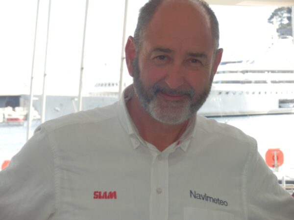
Gianfranco Meggiorin, Navimeteo President and Coordinator
Institutional Weather Centers
The National and International official sources and the Maritime Authorities carry out an extraordinary job of disseminating data, models, bulletins, observations, notices. I believe that investigating the marine weather theme is extraordinarily important in all cases since understanding the weather at sea must be considered a real safety “equipment” on board. It is a subject that deserves dedication. Believe me. We never stop learning.
Technologies are essential but reasoning and experience are certainly needed. All this cannot guarantee that one day we will be able to completely avoid the difficult situation at sea but it will certainly contribute to giving us greater safety and awareness along the Mediterranean routes. Here I thank all the Colleagues of the Navimeteo Team for their extraordinary commitment.