When the Mistral blows
Vuoi salvare articoli per un rapido accesso?
Sali a bordo della community DN Plus.
Per te, un'area riservata con: approfondimenti esclusivi, i tuoi articoli preferiti, contenuti personalizzati e altri vantaggi speciali
Accedi RegistratiThe month of August begins with the Mistral: it will be what in maritime jargon is defined as an intermittent flow

The month of August begins with the Mistral: it will be what in maritime jargon is defined as an intermittent flow
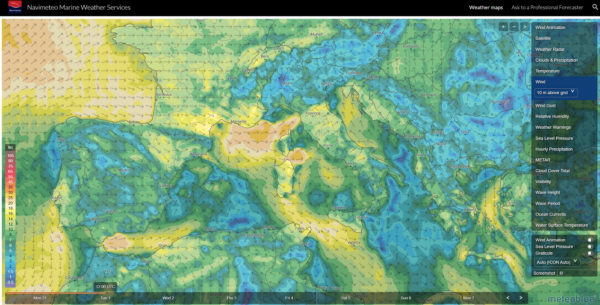
The month of August begins with the Mistral. It will be what in maritime jargon is defined as an intermittent flow, which from the Gulf of Lion spreads with the passing of the hours to Corsica, Sardinia, accelerating in Bonifacio Strait due to the convergence, then blowing through the Sardinia Channel and extending to the Strait of Sicily.
What does intermittent means?
Depending on the variations and differences in pressure, the NW wind will alternate reinforcements and attenuations but since the prevailing direction will remain that of the winds of the IV quadrant, even in moments of “attenuation” the wave motion will remain sustained. In the first days of August, the sea is expected to remain rough on the western sides of the islands and also on the Tyrrhenian coasts.
With a stabilized wind in direction, there are however some interesting and positive aspects to consider for the route choices of yachtsmen. First of all, it is clearer which coasts are exposed and sheltered, the choice of anchorages is easier, although ventilated, it appears stabilized by the prevailing wind.
 The Mistral is also a wind which, after its initial foray, frequently clears the sky which becomes predominantly sunny, considerably mitigating the risk of strong thunderstorms, the great nightmare of sailors in recent Mediterranean summers.
Furthermore, for passionate sailors there is the possibility of exploiting this wind, depending on the pace to be followed, covering many miles with a good push on the sails. Following the weather forecast, it will be necessary to avoid being in exposed areas affected by the warnings. Medium-long term models indicate an attenuation of flows and a barometric rise on 6 and 7 August.
Gianfranco Meggiorin