Thunderstorms at the beginning of summer
Vuoi salvare articoli per un rapido accesso?
Sali a bordo della community DN Plus.
Per te, un'area riservata con: approfondimenti esclusivi, i tuoi articoli preferiti, contenuti personalizzati e altri vantaggi speciali
Accedi RegistratiThe thunderstorms lines are formed in areas where we have upward movement of warm and moist air
The thunderstorms lines are formed in areas where we have upward movement of warm and moist air
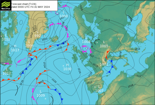
The period of the summer cruises in the Mediterranean begins “formally” this first weekend of June, however skippers will wait the first anticyclonic expansion at least one more week.
While we are following the last atlantic crossings of the big yachts, which in late spring from the Caribbean reposition on the Mediterranean fleeing the imminent hurricane season, unstable air continues to flow relentlessly from the Atlantic to the western Mediterranean, with frequent unstable days characterized by strong thunderstorms.
The cause of this is the persistence of a broad low pressure area centered on the North Sea, which involves southern Europe, with a cold and turbulent Mistral wind, which lashes the Western Mediterranean basins, colliding with the much milder air of the Southern Tyrrhenian Sea and the Ionian Sea.
From Monday, June 3 a gradual anti-cyclonic recovery likely begins, which will ensure greater stability, with a first summer period especially for those who will sail between the tourist resorts of the southern Balearic Islands, Italian Peninsula, Sardinia and Sicily, where we will have the first strong temperature’s rise due to the establishment of an anticyclone centered on the Sardinian Sea.
The thunderstorm’s scientific name is Cumulonimbus, which is a cloud formed by the strong vertical movement of the air masses, which causes the characteristic towering development and the violent phenomena such as wind gusts , heavy showers and hail. The thunderstorms lines are formed in areas where we have upward movement of warm and moist air, moreover greater is the streght of thunderstorms higher is sea temperature and colder is air at high altitude.
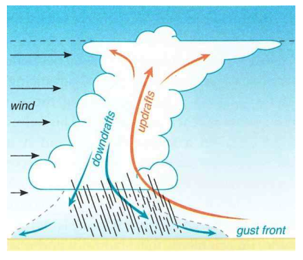
Thunderstorm’s winds – Credits Brooklyn College
For this reason thunderstorms are more frequent on the Mediterranean in summer, when the Mistral or Bora winds, cold and dry, burst on a warm sea on which humid southern winds run, such as Scirocco and Libeccio that come from the African coasts.
The gust front is the most dangerous place during navigation, where there is a sudden change of wind direction, between the incoming air (updraft) rising towards the anvil of the cloud and the outgoing air (downdraft) that descends from the middle of the cloud, creating downbursts, which are strong wind gusts of unpredictable direction and speed.
Alessandro Casarino – Navimeteo