The announced Storm
Vuoi salvare articoli per un rapido accesso?
Sali a bordo della community DN Plus.
Per te, un'area riservata con: approfondimenti esclusivi, i tuoi articoli preferiti, contenuti personalizzati e altri vantaggi speciali
Accedi RegistratiStormy winds, big waves and violent rainfall are causing huge damage and unfortunately also victims
Stormy winds, big waves and violent rainfall are causing huge damage and unfortunately also victims
The weather events associated with the transit of the very deep low of Atlantic origin called Ciaran, with a minimum of 950 hPa on the British Isles and a trough on the Mediterranean, were confirmed to be extremely violent and affected many areas throughout Europe. Stormy winds, big waves and violent rainfall are causing huge damage and unfortunately also victims.
From the point of view of marine weather analysis, some useful points must be highlighted for understanding the phenomenon and this is why we decided to summarize them in a very simplified way.
A forecasted storm
The models, weather maps and forecasts regarding the Atlantic and in particular the British Isles and Western France have “photographed” the weather evolution correctly and well in advance. The warnings were released with regular updates which gradually confirmed the extraordinary intensity of the phenomenon. The same happened also in the Mediterranean.
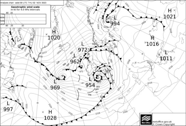
The situation of Thursday 2 November 2023
Extremely violent winds
The depression generated storm-force winds with hurricane-force peaks in the North Atlantic and strong gale-force winds in the Mediterranean.
A very large vortex
The weather maps clearly show the extension of the phenomenon as the depression has extended to affect the entire Western Mediterranean area.
A very deep minimum
Charts and forecast models have indicated very low pressure values of around 950hPa over the British Isles, these numbers are always associated with large storms. In the Mediterranean they drop to around 988 hPa.
A slow movement
The slow movement of the system is equivalent to the persistence of the prevailing winds rotating around the vortex. On the Bay of Biscay as in the Mediterranean, due to the very extensive fetch with the western flows, the waves formed and propagated with great energy, reaching a significant height of over 12 meters in the North Atlantic, with much greater peaks, of around 7 meters on the Ligurian Sea.
An evolving situation
The situation appears to persist in the next few days with a new strengthening of the winds, the sea and the passage of new fronts as highlighted in the Met Office forecast map valid for Sunday 05th at 00 UTC. In the Western Mediterranean the sea will rise again from Libeccio (SW) with strengthening winds up to stormy weather and the transit of a new front. The chart highlights the new minimum of around 960Hpa transiting the British Isles.
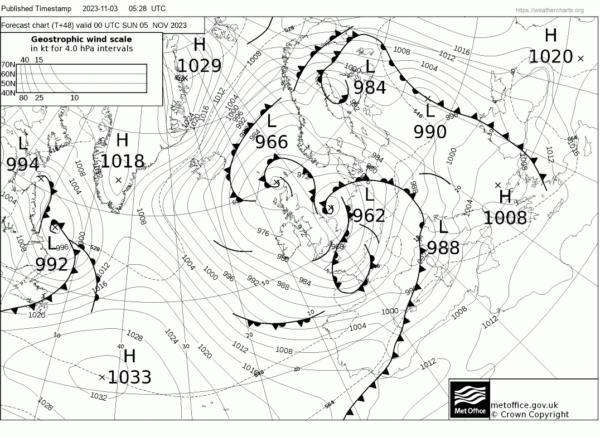
The situation expected Sunday 5 November 2023
Big swell, heavy precipitation and low pressure
The joint action of strong offshore winds and long-period high waves impacting the coasts have a braking effect on the flow of waterways along the coasts and this increases the risk of flooding. Added to this is the effect of rising sea levels due to low pressure since at low pressures the weight of the air on the sea surface is lower.
Shallow waters
Due to the shallow waters, the waves generated by the wind break near the coasts, discharging their extraordinary energy along the coast, sometimes causing problems and often overcoming the breakwater protections of the ports and generating chaotic sea and damage.
There is no doubt that being able to be updated on the evolution of the weather at sea is a very important factor for all those who have to monitor bad weather situations and phenomena of great violence. Safety is the absolute priority for everyone and this sometimes requires ships, transport and port facilities to make difficult decisions, itinerary changes and the adoption of measures aimed at mitigating critical issues.
To delve deeper into these topics in a practical and essential way, the Belle Classe Academy, in collaboration with Navimeteo and other experts in the sector, organizes online training in which anyone who wishes to deepen their knowledge of marine meteorology and the method of acquiring and interpreting weather information can sign up: a topic of great interest and relevance.
Gianfranco Meggiorin and Alessandro Casarino
The waves break and surpass the breakwater of the Port of Chiavari – Video by Gabriele Stagnaro