Monitoring Thunderstorms Online
There are a number of websites that can help us monitor thunderstorms and find out if we will be affected
Vuoi salvare articoli per un rapido accesso?
Sali a bordo della community DN Plus.
Per te, un'area riservata con: approfondimenti esclusivi, i tuoi articoli preferiti, contenuti personalizzati e altri vantaggi speciali
Accedi Registrati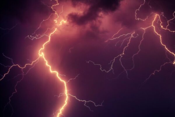
Monitoring Thunderstorms Online
There are a number of websites that can help us monitor thunderstorms and find out if we will be affected
Vuoi salvare articoli per un rapido accesso?
Sali a bordo della community DN Plus.
Per te, un'area riservata con: approfondimenti esclusivi, i tuoi articoli preferiti, contenuti personalizzati e altri vantaggi speciali
Accedi RegistratiAfter having made some distinctions between the different types of storms, I would now like to give you some references to be able to monitor the development of these phenomena that increasingly occur on our seas especially in the summer season.
There are some websites that can help us understand if there is a likelihood of a thunderstorm affecting our area, port, anchorage or route.
I would suggest consulting the following websites in this order:
a) Synoptic maps
Those elaborated by the Met Office are clear and essential and have always been a very useful support for sailors since the time when, without the internet, the only way to receive them on board was via radio through a radiofax device tuned to the frequencies of one of the National Centers.
Cold fronts and lines of instability are the two most marked signs of the probable development of the storm and associated phenomena which are lightning strikes, precipitation, gusts and stormy winds. The greater the thermic differences between the hot air (on the surface of the coasts and the sea) and the cold air that arrives, the more active and intense the thunderstorms will be.
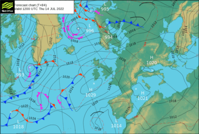
MET OFFICE WEATHER MAPS
b) Satellite images
Meteosat images once required reception antennas to be viewed. Today they can be consulted on the web and allow you to see the clouds, their development and displacement with extreme clarity. A practical site to be able to follow the movement of these cloud systems in the “near” Atlantic and in the Mediterranean is that of the Servizio Meteorologico dell’Aeronatica Militare. There are different types of cloud visualisation systems which vary according to the radiometric satellite detection system (mainly water vapour and infrared). It is possible to view the “slow motion” sequence which provides a good indication of the direction and speed of movement of the cloud systems. The clouds that appear whiter and more contrasted are those indicating clouds with a strong vertical development, the cumulonimbus clouds. The contemporary analysis of the wind flow helps to better understand the expected evolution.
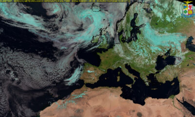
METEOSAT METEOAM
c) Detection of lightning strikes
Although it is not always possible to associate the presence of lightning with the development of the storm, it is clear that being able to monitor lightning, its frequency, diffusion and movement helps to understand if the phenomenon will also affect our maritime area of interest. Many of these “lightning detection” systems are freely accessible on the web, other more professional and sophisticated systems that use complex algorithms, are instead used by private centres needing greater detail, especially on the extent of the phenomenon and probable displacement. Experience shows that very frequently the strongest gusts are associated with the arrival of the most developed storm cells. The medium-term forecasts provide an index of instability and probable storms and precipitation with gusts of wind, the “nowcasting” technique focuses on the observation and monitoring of the storm phenomenon practically in real time.
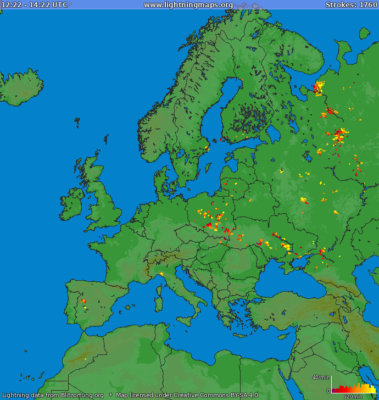
The Blitzortung Strike Map
d) Radar
While the satellites show the clouds seen from space, radar on board (for boats with it installed) or via the web through the various public sites, allows you to monitor rainfall, its intensity, and displacement – which can vary significantly depending on whether the cumulonimbus are more or less active.
The different radars cover large areas of the Mediterranean and allow us to better interpret the movement of a perturbed system, a cold front or a more localised line of instability.
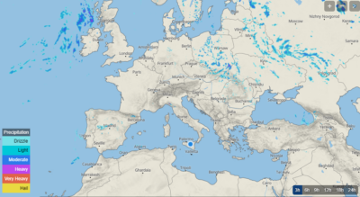
METEOBLUE SAT & RADAR
Gianfranco Meggiorin
Navimeteo