
Forecasting the Mediterranean thunderstorm
Learn how to identify the different types of thunderstorm you might encounter in the Mediterranean Sea
In the summer season, the thermal energy accumulated on the surface of the sea and coasts represents an extraordinary engine for the formation of the characteristic thunderstorm phenomena. Experience teaches us that when there is a prolonged warm and sunny period on the Mediterranean, generated by an extended low gradient anticyclone, (i.e. with a moderate circulation of winds), the surface temperature of the sea often rises above 25 ° C and the air temperature often rises above 30 ° C.
In this “stagnation” of hot and humid air, with predominantly sunny weather, coastal breezes dominate and partially mitigate the effects of heat. In this situation, the weather and sea conditions are manageable, but we know that the scenario could change dramatically with the incursion of a cold front or a line of instability.

Thunderstorm front clouds
The Mediterranean in summer is the sea of thunderstorms and, especially in recent years, thunderstorms are the phenomena that most often have put sailors in difficulty as they have become more difficult to predict, sudden and associated with gusts of extraordinary intensity. For this reason, I would like to help you learn how to distinguish and understand the evolution of this event on the sea and on the coasts. We could divide the thunderstorms in the Mediterranean into three main categories.

Alessandro Casarino and Danny Vitri two Senior Forecasters at Navimeteo
Coastal thunderstorms. We could define them as “good weather” thunderstorms. They form in the summer along the coasts, especially in the sunny summer months and in the hottest hours of the afternoon-evening. They dissolve at night. The clouds develop upwards like huge towers, due to powerful convective motions, the heating of the coasts and the flow of sea breezes. Once they have reached their maximum development, they are able to discharge gusts and precipitation at their base and in the proximity areas. They often form in anticyclonic conditions, are not foretold by marked pressure variations, are localized and do not travel far, remain on the narrow coastal zone, and are not accompanied by a significant increase in wave motion since the wind is very local.
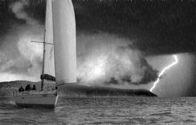
A thunderstorm near the coast
The storms of the lines of instability. When there is an incursion of colder air in an area of hot and humid air, on land or on the sea, lines of stormy instability are created, usually announced by bulletins or highlighted with a marked line on weather maps. These storms can travel indifferently on the coasts or on the sea and surprise boats especially during a quiet anchorage in the harbor, since they can also occur within an anti-cyclonic area where the sea and the wind are generally good. Gusts and associated phenomena, including sea trumpets can be very violent. Sometimes the anchorage becomes unsustainable and forces sailors, if surprised, to decide whether or not they should get themselves to greater safety by going out to the open sea away from the coast.
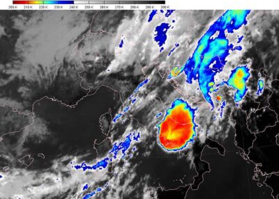
The storm seen by the Eumetsat satellite
The frontal thunderstorms. In this case it is the irruption of a strong “flow” of cold air on a warmer area. Their arrival is generally forecasted clearly and in advance, but the cold front is driven by the strengthening of the winds and the increase in the state of the sea. The sky becomes dark and is covered with cumulonimbus clouds over a very extended horizon. They are often sustained by strong gale force winds that persist even for several days. The winds blow even after the front despite the bright spells. The arrival of the cold front is accompanied by marked variations in the value of the pressure which returns to rise decided precisely when the cold front passes.

Majestic cumulonimbus – credit NOAA
Gianfranco Meggiorin